Showing posts with label USS Restless. Show all posts

Monday, February 17, 2014

St. Andrews Bay Salt Works Raids Again

Historic marker in a public park in Panama City describing the salt works raids. Author's photo.

In a post in December (December 2013 post), we called attention to a major Union Navy raid on the Confederate salt works in St. Andrews Bay. Because of the critical importance of salt, the Confederates very quickly rebuilt the salt works in St. Andrews Bay after the Union forces departed. The southerners would not give up!  Escaped slaves told Acting Master W.R. Browne of the bark USS Restless about this, and that additional material was being transported down the Wetappo River to build larger works in the Bay. He sent in two parties of his men to again destroy these works. Browne reported on 17 February 1864:

Learning that the rebels had erected new Government salt works on West Bay, on the site of the old salt works destroyed by us in December, and that they had a force of 50 men armed and stationed there for protection, I fitted out the first cutter, manned with 13 men, under charge of Acting Ensign James J. Russell, with orders to proceed up the Gulf coast 20 miles, and march inland 7 miles to the salt works and attack them in the rear, while Acting Ensign Henry Eason with 10 men, in command of the second cutter, would proceed by the inside passage and attack them in the front at the same time.

The expedition was entirely successful, the works being abandoned upon the appearance of our men, Messrs. Russell’s and Eason’s party joining at the appropriate time, and immediately proceeded in the destruction of everything in the manufactories, consisting of 26 sheet-iron boilers, averaging 881 gallons, and 19 kettles, averaging 200 gallons, making an aggregate of 26,706 gallons, which cost in Montgomery $5.50 per gallon.”

The redoubtable Browne would send in additional raiding parties in March and April 1864. His determination and initiative earned him a promotion to Acting Lieutenant.

Saturday, December 7, 2013

St. Andrews Bay Salt Works Raids 1863


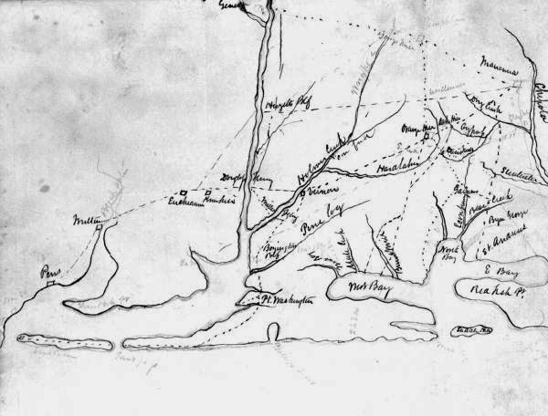
1860's sketch of the Florida coast showing St. Andrews Bay (lower right). Source:  Florida Dept. of State photo archive.

In earlier posts (3 Feb 2012 and 4 Oct 2012) we highlighted the importance of salt to the Confederacy, Florida’s role as a main producer of salt, and the Union Navy’s efforts to destroy salt works along the Florida gulf coast. In his book “Blockaders, Refugees and Contrabands. Civil War on Florida’s Gulf Coast”, George Buker notes that the initial salt works raids were harassing efforts, conducted incidental to other blockade activities. The strategic importance of salt to the Confederacy was not apparent to the East Gulf Squadron command until they noted that nearly every blockade runner captured contained salt as at least a portion of its cargo. It was then that the squadron command realized that a concentrated effort to find and destroy these works would be a major strategic blow to the Confederate war effort. In December 1863 these focused raids began, concentrating on the epicenter of Florida salt production, St. Andrews Bay.

On 2 December 1863 the bark USS Restless, Acting Master William R. Browne commanding, sent a landing party in to Lake Ocala in St. Andrews Bay. They found three separate works with a total capacity of 130 bushels per day. The landing party destroyed carts and flat boats, disposed of the salt, and took 17 prisoners, whom they released because they didn’t have room to bring them back to the gunboat. They made the southerners swear an oath of allegiance to not take up arms against the Union.

Hearing of Browne’s exploits, Acting Ensign Edwin Crissey, commanding the steam gunboat USS Bloomer, sought out the Restless and offered to assist Browne and his ship. Crissey and his ships were actually with the West Gulf Blockading Squadron, but his proximity to the East Gulf Squadron’s operations area enabled him to help there. On 10 December 1863, the USN flotilla entered St. Andrews Bay and split up into two enterprises. Browne fired two shells into the town of St. Andrew (present-day Panama City) to warn the Confederate soldiers and salt workers garrisoned there. He then commenced shelling the town, which shortly was burning. The entire town was destroyed by the fire.

Crissey and his men landed in West Bay and proceeded to the salt works there. From his report dated 20 December 1863 he described a major raid on these:

 At 5 p.m. I proceeded to the salt works on West Bay, destroying the salt works lined on each side of the bay for 7 miles, belonging to private individuals, numbering at least 198 different works, each averaging two boilers and ten kettles each, which, with a large quantity of salt, were destroyed. . . . . On the afternoon of the 14th we came to a large Confederate Government works, under the command of Mr. Clendening, which turned out daily 400 bushels of salt. This was one of the best located in West Bay, being situated in a marsh, the water of which yielded 75 gallons of salt to 100 gallons of water; it was, in fact, a complete salt village, covering a space of three-fourths of a square mile, employing many hands and 16 ox and mule teams constantly to haul salt to Eufola Sound [Eufaula, Ala?], and from thence conveyed to Montgomery, at which place it is selling at a fabulous price of $40 and $45 per bushel. At this place were 27 buildings, 22 large steam boilers, and 200 kettles, averaging 200 gallons each, which cost the Government $5 per gallon, all of which were totally destroyed, together with storehouses containing salt, etc. This work, together with the other works, could not have cost less than three million dollars.”

Notable from this report is Crissey’s description of one of these works as “a complete salt village” and his estimate of the total value of the works he destroyed, on the order of $3 million. In today’s dollars that would certainly translate into tens of millions.

An 1886 Navigation Chart of St. Andrews Bay is on the NOAA historical maps site at:
http://historicalcharts.noaa.gov/tile /zoomifypreview.html?zoomifyImagePath=LC00184_12_1886 . A living history event, the St. Andrews Bay Salt Works Raid, is held in April in Panama City to educate folks about these Union Navy raids and the importance of salt to the Confederacy.

Replica salt kettle at a park in Panama City, FL commemorating salt production during the Civil War.

Saturday, July 6, 2013

Union Navy Expedition up the Peace River, Florida

Print showing a sloop of the configuration of the USS Rosalie. Source:  Library of Congress on-line image library.


The coast of southwest Florida, from the Keys to Tampa Bay, was practically uninhabited through much of the Civil War, almost the very definition of “remote.” Small fishing villages appear to have existed at Ft. Myers and Punta Gorda, along with a few hardy souls living in camps on some of the old Calusa Indian shell middens scattered throughout Pine Island Sound and the Ten Thousand Islands region to the south. The coast was part of the patrol sector of the East Gulf Blockading Squadron. The major water body in this region was the estuarine bay Charlotte Harbor. Two rivers, the Peace and Myakka, drained into this bay from the state’s interior. Just south of the entrance to the bay, the Caloosahatchee River emptied into San Carlos Bay. Because of its remoteness, the region proved irresistible to blockade runners and did see some activity.

On 6 July 1863, Acting Master W. R. Browne from the bark USS Restless took on board two white refugees from the area. They told him that two Confederate blockade runners had attempted a run out that morning. Browne sent out a party of 36 men in the bark’s two cutters, under the command of Acting Ensigns Eason and Russel and Acting Master’s Mate Browne, guided by the two refugees. Their objective was to find the sloop USS Rosalie, with orders for her commander Acting Ensign Charles P. Clark, and then with the Rosalie attempt to locate the runners. The Rosalie was supposed to be stationed in Pine Island Sound. Rosalie in this case was not the larger "sloop-of-war" such as the USS Cumberland; she was a shallow-draft, single-masted sailing ship. She was actually a captured blockade runner and highly useful in the shallow inshore waters of southwest Florida. She was armed with a 12-pdr Dahlgren boat howitzer.

The boats from the Restless did not find the sloop in this location, and so they headed up the Peace River to the small settlement of Punta Gorda. The next morning, they sighted the Rosalie about 5 miles upriver. Upon pulling up to the sloop, they were told by Ensign Clark that he had moved the sloop to the mouth of the river. About 9 AM the morning of the sixth, he saw a sloop and a schooner making a run up the river (probably they had been on their way down when they sighted the Union gunboat and “turned tail”). He set off in pursuit, but it was his misfortune to ground the sloop on a sand bar in the river. The Confederate runners continued upstream, no doubt having a better knowledge of the river channel. By the time the Restless’ boats had reached the Rosalie, Clark had succeeded in freeing her from the bar. The boats and the sloop continued upriver, until shoal water would not allow the sloop to proceed further on the evening of the seventh.

Clark anchored for the night, at this time about 45 miles upriver. The next morning, 8 July, Clark left the sloop in charge of Acting Master's Mate Browne, took command of the two Restless boats, and pushed further upriver to Horse Creek, where they found the two runners unmanned. They were the Bahamian schooner Ann and an un-named sloop, both loaded with cotton. The naval expedition took possession of the two runners and their cargo and made their way back down to the Rosalie, then back out the bay to rejoin the Restless the afternoon of 9 July. For their actions, Adm. Bailey issued a letter of commendation to Acting Master Browne and the crew of the Restless, and promoted Clark from Acting Ensign to Acting Master.


An 1868 Navigation Map of the Charlotte Harbor entrance is at:  http://historicalcharts.noaa.gov/tiled/zoomifypreview.html?zoomifyImagePath=CP1121C